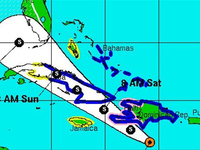
Santo Domingo.- the Emergency Operations Center (COE) Friday said the entire country continues under alert, with 22 of the 31 provinces still under a Tropical Storm warning , while T.S. Isaac was located 265 kilometers south the country.
It said 2,878 people have been evacuated from their homes in high risk areas because of the storm Isaac, with 296 taken to shelters in San Juan, San Cristobal and San Pedro provinces.
The COE cautions the population to remain vigilant as the worst of the storm has yet to come, including heavy downpours this afternoon. “Several areas of the country have been cut off among them Samana and Sanchez Ramirez.”
It adds that forced evacuations will continue.


hazards affecting land
----------------------
rainfall...total rainfall accumulations of 8 to 12 inches...with
maximum amounts of 20 inches...are possible over hispaniola. these
rains could cause life-threatening flash floods and mud slides.
total rain accumulations of 4 to 8 inches...with maximum amounts of
12 inches...are possible across jamaica...the central and eastern
portions of cuba...the florida keys and the southern peninsula of
florida. total rain accumulations of 2 to 4 inches are possible
over the central and southeastern bahamas.
wind...tropical storm conditions are spreading over portions of the
dominican republic and haiti...with hurricane conditions possible in
haiti. tropical storm conditions are expected over the southeastern
bahamas and the turks and caicos islands tonight...are expected
over the central bahamas by saturday or saturday night...and are
expected over the northwestern bahamas by sunday. tropical storm
conditions are expected over ea
conditions are expected to reach northwestern cuba and the
northwestern bahamas by saturday night or sunday...and south
florida and the florida keys on sunday. hurricane conditions are
possible over the florida keys...florida bay...and the southernmost
florida peninsula by sunday evening.
storm surge...the combination of a storm surge and the tide will
cause normally dry areas near the coast to be flooded by rising
waters. the water could reach the following depths above ground
if the peak surge occurs at the time of high tide...
south florida including the florida keys...2 to 4 ft
hispaniola and eastern cuba...1 to 3 ft
the bahamas and turks and caicos...1 to 3 ft
the deepest water will occur along the immediate coast in areas of
onshore flow. surge-related flooding depends on the relative timing
of the surge and the tidal cycle.
the deepest water will occur along the immediate coast in areas of
onshore flow. surge-related flooding depends on the relative timing
of the surge and the tidal cycle...and can vary greatly over short
distances. for information specific to your area...please see
products issued by your local weather service office. near the
coast...the surge will be accompanied by dangerous waves.
surf...dangerous surf and rip current conditions will affect puerto
rico...hispaniola...the bahamas...the turks and caicos...eastern
and central cuba...and the east coast of florida and the florida
keys during the next couple of days. please consult products from
your local weather office for more information.
May God protect all people in the path of this storm, Puerto Rico, Dominincan Republic, Haiti, Jamaica, Cuba, Turks Calicos and the Bahamas.